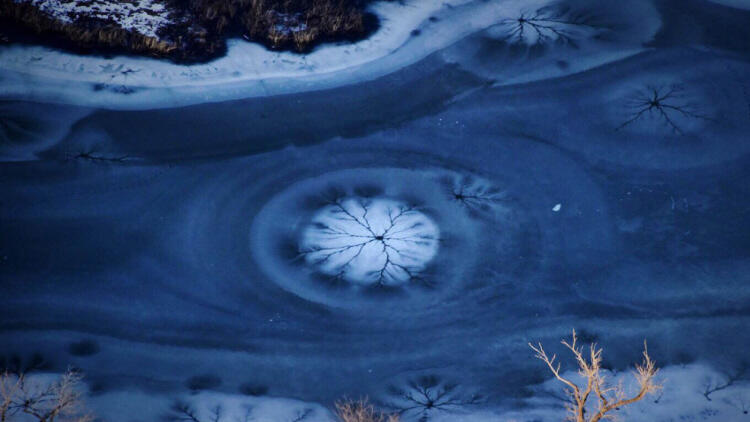
Cburn, I’ve attached an aerial image from last Friday evening [above]. This one looks at a powerful spring pushing up through the ice of a Platte River backwater. I’ve seen this on a very small scale walking frozen creeks in winter fed by groundwater, but this was quite amazing at 800 feet. Groundwater is difficult to capture in a beautiful way in an image. I guess it takes getting up in the air sometimes to see it. Mike, I’ve been corresponding with photographer Mike Forsberg for many months, learning about his impressive project, the Platte Basin Timelapse, which photographically follows water in Colorado, Wyoming, and Nebraska from the mountains to the plains, in an attempt to capture a watershed in motion. Often in his emails he includes a recent photo and story from his travels. Like this one: Coburn, Here’s an aerial view of the Platte River in Nebraska. This is the welcoming view that 500,000 migrating cranes will soon see as they begin to wing northward through the heart of the Great Plains. Mike ***** I told Forsberg that every photo he sends me is a gift. And I mean it, because Forsberg is the kind of guy who makes you feel like every picture he sends, and every story he tells, is personal and special. So magnify that special sense of storytelling on a grand scale, and you get the Platte Basin Timelapse (or PBT as the team calls it). It’s a project so impressive in scope that it’s almost hard to sum up. The PBT website contains time-lapse images from around the 90,000-square-mile watershed, multimedia stories, a detailed map showing the location of the cameras, and an entertaining blog written by team members, some of whom are students at the University of Nebraska. (One post is titled “How to Take Hundreds of Thousands of Images and Not Go Insane.”) They are also working on an education component for schools, as well as a feature-length documentary. “[We’re] simply trying to get people to understand, when they turn on that faucet and fill up that glass, that water is actually coming from somewhere,” says Forsberg. “And in a lot of cases that place is actually a long ways away, and how it gets to your glass is a really interesting journey. Where does that water come from? How is it used? Who makes those decisions? And why?” In short, Forsberg, co-founder Mike Farrell, and their team are trying to show change over time, and to make you realize how truly precious your water is, whether you live in the Great Plains or on a coast far away. To make that happen, the PBT team set up more than 40 Nikon digital cameras in solar-powered waterproof housings, mounted on everything from granite cliffs, to posts in the sand, to along prairie streams. Each camera takes one picture per hour, from sunrise to sunset, every day. By the end of this year Forsberg says they will have more than a million images in their archive. They then string those images together to form time-lapse videos that capture the changing watershed over a number of years. “Everything that we are doing is trying to see a watershed in motion, trying to explain what a watershed is, to get people to understand that nature doesn’t know any straight lines, neither does water, and a watershed is a living breathing organism that is constantly changing,” says Forsberg. Amazingly, and unexpectedly, the project captured the Platte Basin at both ends of the water spectrum—one year in a flood situation, and the other in a drought. Over four years, the image-gathering process has gone through some changes. At first, the team was manually retrieving the digital cards and cataloging all the images by hand. But it didn’t always work smoothly. “We’d sometimes come back a few months later to find the camera wasn’t working, or a bird had pooped on the filter, or a mouse had chewed on a cord, or the camera post had fallen over,” says Forsberg. Now, the cameras send images directly to a server in Lincoln, Nebraska, via cellular network or satellite, and the team’s biggest problems are curious wildlife and spiders building webs in front of the lenses. Forsberg says he was inspired, in part, by photographer James Balog’s Extreme Ice Survey, which takes time-lapse images of glaciers to show the impact of climate change. “Photography is a really powerful tool, and it’s an international language so everyone can understand it,” he says. “The Platte Basin doesn’t have to be your watershed, but [the stories] can be applied to any watershed in the whole world, whether it’s a creek in your backyard, or the Zambezi in Africa. It’s just a way to communicate, whether it’s to my mom or to a highbrow scientist.” “It’s something that’s very personal to me as a photographer,” he continues. “You go to a place to shoot something and your subject says: ‘You should have been here yesterday, or last year, or five years, or ten years ago. You should have seen it then.’ You can’t go back in time to those places, but you can do that now with time-lapse photography moving forward.” (National Geographic)
![]()