Europe’s Sentinel-2a satellite is on course to go into full operation in early or mid-October.
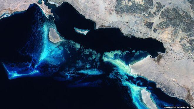
The spacecraft, which takes visible and infrared pictures of the Earth, was launched in June and is now undergoing a period of commissioning. The observer is the second dedicated mission to fly in the European Union’s Copernicus programme. This will see a multi-billion-euro series of satellite sensors put in orbit over the next few years. Sentinel-2a, however, will be the system’s backbone, producing a wide range of imaging products that will focus predominantly on the planet’s land surface. The European Space Agency, which led the development of the platform, released a taster on Monday of what to expect. These views ranged from cities and forests to glaciers and coral reefs.
‘Carpet mapping’
“They are stunning,” said mission manager Bianca Hoersch. “Okay, we still have some calibration work to do, on co-registration between visible and shortwave infrared bands, but I think you can see just from this release that the quality is going to be really excellent.” Sentinel-2a is the European equivalent of America’s Landsat mission, which has been imaging the surface of the Earth for 40 years. The US satellite’s data is free and open, which has driven a multitude of applications. Most people will probably know it best from the map tools they use on their computers and smartphones. These all incorporate Landsat pictures. Sentinel’s data has been designed to be complementary, but the platform also represents a big jump in capability. Its imaging instrument will be sensitive across more bands of light (13 versus Landsat’s eight), allowing it to discern more information about the land beneath it; and Sentinel-2a will “carpet map” a much wider strip of ground (290km versus 185km). In addition, its colour images have a best resolution of 10m, versus Landsat’s 30m. Given that today, non-specialist use of Earth imagery overwhelmingly relies on Landsat data, it is more than probable that Sentinel products will be in big demand. The European Commission will be using Sentinel pictures in its Copernicus programme to run variety of services, reaching across agriculture and forestry, urban planning and disaster mitigation. Agriculture, though, is certain to be a big user. The satellite’s camera sensor has been designed to detect very specific wavelengths of light that detail the health of plants. In normal operation, Sentinel-2a will be producing 1.7 terabytes of processed data per day. And this will double when the sister satellite, Sentinel-2b, is launched next year. “The data volume is incredible,” Dr Hoersch told BBC News. “Of course, we all knew it would be like this, but when you sit there with your computer and try to download it, it’s massive – gigabytes of data. I had to go out at the weekend and buy a hard disk to store all these products for my presentations.” Esa will launch Sentinel-3a at the end of 2015. This satellite is dedicated to observing the oceans.
![]()