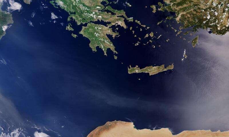

The above image is not any map you come across usually. It is a picture captured on the 10th of May by Sentinel-3A satellite, showing a number of countries in the Mediterranean Sea.
Information about Crete island:
- Largest and most mountainous of the Greek islands
- Located in the south part of the Aegean Sea
- Covers an area of 8,939 sq.km
- Characterized by its rocky spots surrounded by a beautiful mountain range including the White Mountains, Mount Psiloritis, and Dikty Mountain
- Crete lies at the spot where the continents of Europe, Africa and Asia meet and is divided into four regions: Chania, Rethymnon, Heraklion and Lassithi
- The mounatins of Crete draw the attention whether you look from the west, east, north or south
- The famous White Mountains have more than 52 peaks and Mount Psiloritis is the highest peak in Crete.
- Home to hundreds of migratory bird species and some small wild animals
Back to the picture, revealing Northwest of Crete, where there is a large part of Greece’s mainland, showing dense vegetation and agricultural landscape, while under the clouds a small part of Italy’s ‘heel and tip’ are visible.
Parts of southwestern Turkey are revealed at the top right of the picture, indicating a mixture of agricultural landscape and mountainous regions, where bare soil and rock formations prevail.
Libya’s arid desert is shown at the bottom of the picture, with the Saharan plateau comprising some nine-tenths of the country, making it truly a sea of sand.
Sentinel-3A was launched last 16 February, and it carries four instruments working together, making it the most complex of all the Sentinel missions.
According to Phys.org, the satellite’s Ocean and Land Colour Instrument offers a new eye on Earth, monitoring ocean ecosystems, supporting crop management and agriculture, and providing estimates of atmospheric aerosol and clouds – all of which will bring significant benefits to society.
Facebook: greenarea.info